
Charts & Publications

6 Item(s)
Grid List
-
-
Terminal Area Charts (TAC)
$6.99Depict the airspace designated as Class B airspace. The information found on these charts, while similar to that found on Sectional Charts, is shown in much more detail because of the larger scale. Learn More -
FAR/AIM
$29.99The Industry Standard Reference for Federal Aviation Regulations Relevant to General Aviation, Sport Pilots, Instructors, and Unmanned Aircraft System (UAS) operators
Learn More -
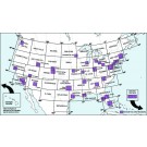
Pilot's Atlas USA
$34.99Base cartography is the US Road-Atlas 1: 2.000.000 which includes mountain ranges, lakes, rivers, etc. . As well, all other elements such as, cities, towns. Parks and points of interest or historic value and of course, the railways and motor-ways themselves.
Learn More
To this, we have added all airports in USA (over 5,500) and colour coded them by runway length /surface and category ,ie. International, Regional, Civil/Military, etc.. VOR/DME , Reporting points, Waypoints), Volmet frequencies and special Use Airspace are also shown making our new "Pilots' Atlas" the first of it’s kind. -
FAR/AIM
$19.99The Gleim FAR/AIM simplifies and facilitates your understanding of the complex rules governing aviation.
Learn More -
Sectional Aeronautical Charts
$8.99These charts are updated every six months, most Alaska Charts annually. U.S. pacific territories including Guam, Mariana Islands and the Samoan Islands are included on the back side of the Hawaiian Sectional Chart.
Learn More


6 Item(s)
Grid List